
Workshop: Drone applications in sustainable natural resources management
Date and time
Location
Rungan Sari Meeting Center & Resort
Palangka Raya, Kalimantan Tengah 73225 IndonesiaRefund Policy
Description
Learn all advantages and challenges of using drones for sustainable ecosystem management, in particular forestry. The 5-day workshop will consist of a theoretical and practical part. In the theoretical part, participants will study the basics of drones and their typology. They will get familiar with different available sensors and their respective fields of application. In the practical part of the course, the participants will have the chance to learn how to plan, prepare, perform and evaluate a mapping mission based on a live demonstration on the field. Finally, the acquired data will be processed using photogrammetric processing to generated orthophotomaps and DEMs.
Download the announcement brochure here
To see the full price list, please click on the Register button.
Background
The implementation and preservation of sustainable forest systems as efficient carbon storages play an essential role in the mitigation of climate change. Although it is more than clear that there is an urgency in dynamizing the sustainable use of forest and ecological resources in general, the potential is far from being fully exploited. One of the reasons for the slow transformation of the forest sector towards more sustainability is related to the lack of a solid information basis, a prerequisite for any successful long-term planning. In the past, the collection of data lied in the hand of a few and the access to it was costly. With the appearance of new technologies like drones and the digital revolution in recent years, information has become more accessible to a broader public. This democratization of data represents a unique opportunity to empower actors in the field. Whether state or private organizations, smallholders or NGOs, equipped with the right information tools, they can improve their environmental governance.
Drones: democratizing the access to data from the sky!
Remote sensing imagery has been for a long time an essential tool for monitoring changes in vegetation cover. It allows following the human impact on the environment, such as deforestation, or forest restoration efforts. Classical data sources, like satellite imagery, do not always provide sufficient resolution and currentness and can have high costs. Unmanned Aerial Vehicles (UAV), also known as drones, have opened a completely new access to high-quality aerial imagery. Due to relatively low costs and ease of use, drones have become an essential tool for professionals in the field of natural resource management. Drone-based mapping delivers high-resolution orthophotomaps, Digital Elevation Models (DEM) and 3D models which can be further analyzed. Equipped with this data, forest managers are able to make better decisions, scientists can study the consequences of climate change more efficiently and indigenous people are enabled to monitor their territories.
The implementation of drone systems for ecosystem management.
Despite the mentioned advantages of this new technology, its application in the fields of conservation, forestry, and environmental studies is still relatively slow compared to other sectors such as agriculture. Reasons for this are mainly:
-
Lack of awareness of decision makers about the potential of drones.
-
Limited technical knowledge of organizations and individuals on how to use drones. This leads to false decision making and equipment usage, in many cases with fatal consequences, discouraging many users to proceed the work.
The goal of the present workshop is to eliminate these barriers and prepare participants to be future operators. It will introduce the basics of civil drones and their application in the field of conservation, forestry, and environmental studies. At the end of the course, each participant will be in a position to acquire and start to operate its own drone system.
 Target audience
The workshop is aimed both for those who have no experience with drones as well as for operators who want to deepen their knowledge. The target participants are representatives of NGOs, academic institutions, governmental environmental agencies and companies active in the field of forestry and agriculture.

Agenda
The workshop will last for five days and will consist of a theoretical and practical part. In the theoretical part, participants will study the basics of drones and their typology. They will get familiar with different available sensors and their respective fields of application. In the practical part of the course, the participants will have the chance to learn how to plan, prepare, perform and evaluate a mapping mission based on a live demonstration on the field. Finally, the acquired data will be processed using photogrammetric processing to generated orthophotomaps and DEMs.
Day 1: Monday, 15h May
-
Introduction to drones and their typology.
-
Sensors (RGB, Multispectral, Heatsensonsors, LiDAR, …)
Day 2: Tuesday, 16th May
-
Applications (Conservation, Forestry, …)
-
Introduction to photogrammetry
-
Mapping
Day 3: Wednesday, 17th May
-
Mission planning
-
Virtual piloting training
Day 4: Thursday, 18th May
-
Drone preparation
-
Demonstration of a mapping mission
-
Georeferenciacion of the aerial images
Days 5: Friday, 19th May
-
Photogrammetric process
-
Integration in GIS project
-
Legislation
A more detailed description of the different modules can be found here.
Note: The program might be subject to smaller changes depending on the focus set by the participants or weather conditions.

Personal training
In addition to the workshop which will take place between the 15th and 19th of May, it is possible to organize a two-day personal training during the week starting the 22nd of May. This training is based on the principle 'learning by doing'. The participants will plan and carry out mapping missions themselves using an open-source-based fixed wing drone system. The aerial imagery will be processed using a photogrammetric software. Each training is limited to max. 3 persons.
If you are interested in this additional offer, please send an e-mail to droneworkshop@openforests.com to receive more information.

About the Instructor
Dr. Patrick Ribeiro is co-founder and CEO of OpenForests. He is responsible for the development of drone-based forestry and conservation application as well as the execution of mapping missions. Patrick has been working with drones for the past 7 years in countries such as Germany, Portugal, Costa Rica, Panama, Colombia, Ecuador, Peru, Suriname, and Indonesia.
"In my most recent encounters with first-time users of drones, such as biology students, foreign development assistance employees or CEOs of plantation companies, I have detected over and over again the same beginner mistakes, starting with the acquisition of incompatible drone systems for a certain applications, e.g. wanting to map thousands of hectares with a small consumer-grade quadcopter, vehicle lost due to an imprudent mission planning or bad data processing as result of wrong flight settings. One of the major goals of my workshop is to sensitize future drone owners and operators about these typical mistakes, allowing them to avoid having to go through the same unpleasant experiences. At the end of the workshop participants will be equipped with the knowledge needed to carry out successful drone missions."
Download Patrick's CV here.

FAQs
-
In which language will be the workshop be held?
The workshop will be held in English. Basic English skills are required.
-
What's the refund policy?
Every registered participant is entitled to cancel its registration until the 31 of March with full refund. After that, refunding will be partial according to the following rules:- 1st - 9th of April: 75% refund of total paid value
- 10th - 16th of April: 50% refund of total paid value
- 17th - 23rd of April: 25% refund of total paid value
Note: Consider transferring your ticket to another person. Please refer to the next question. -
Is my registration/ticket transferrable?
It is possible to transfer your ticket to another person as far as this person is entitled to own that ticket. I.e., considering the three participant group types
a) company employees and government members
b) non-profit organization's members and university employees
c) students
the following rules apply:
A registration ticket of group type a) can be transferred to another person of group type a), b) or c). A registration ticket of group type b) can be transferred to another person of group type b) or c). A registration ticket of group type c) can only be transferred to another person of the same group type c).
IMPORTANT: Please notify immediately any change of the ticket holder so we can confirm the validity of the transfer. -
What are my transport options for getting to and from the workshop site?
The transport from the airport or Palangka Raya city center to the place of the workshop and back can be made with taxis. A one hour ride has to be expected. Depending on the arrival schedule of the different participants, we will organize collective transportation, if wished. Please get in touch with us to clarify needs. -
Do I have to bring my printed ticket to the event?
No, a document with your ID will be enough. - Which drones will be used during the demonstration?
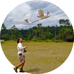
We will be using multi-copters as well as fixed wings. The main mapping demonstration will be carried out with a fixed-wing. The employed model is a cost-efficient DIY (Do-It-Yourself) drone based on open-source technologies and components easily obtainable on global markets. For comparison purposes, we will also demonstrate the execution of a mapping mission using an easy-to-use commercial drone.
-
How can I contact the organizer with any additional questions?
You can send questions via e-mail to droneworkshop@openforests.com or share your questions in one of our groups: @LinkedIn @Facebook